Introducing Velorino: your cycling companion for tours in Austria
Side-projects
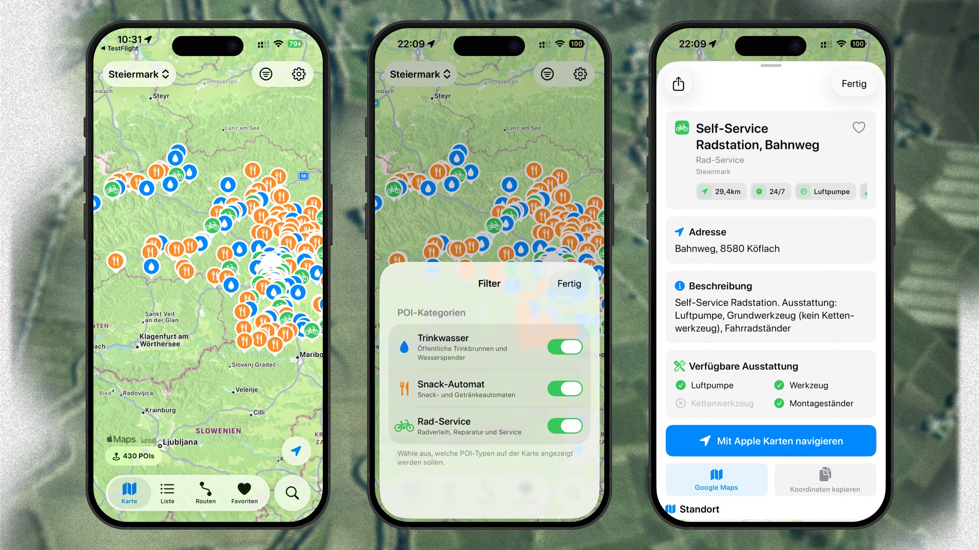
View POIs around you, analyze your own routes, and find the next snack station.
Avid readers of my blog or followers of my social media accounts might already know that I am a passionate hobby road cyclist. That passion led to building projects like Podium. However, being a fan of the sport, following the professionals, and soaking in almost everything when it comes to cycling, recently led to me to building another project with a dedicated cycling focus. Whenever I am out on a cycling tour, I am trying to test my limits, aiming for 80, 90, or even over 100km. As I am a bit limited when it comes to carrying water bottles, snacks, and tools, I wanted a quick and easy way to find spots near my current position where I can refill my bottles, grab a quick snack, or have access to additional tools in case I need to fix something on my road cycle.
Throughout Austria, we have an extensive public water dispenser system. Additionally, there are several snack stations offering food and drinks, operated either by companies or individuals, especially farmers who are offering for example their own fresh produced juice through such snack stations. And besides that, multiple cities as well as different institutions are maintaining self-service bike stations, open 24/7, and providing access to all the tools you need to quickly fix any smaller issues on your cycle while being out for a ride. Some of those POIs are available in apps like Apple Maps or Google Maps, but others are not.
And then, those apps can feel clunky and bloated, especially when I am only searching for a specific category of POIs. Relying on Apple Maps while being out for a ride has also led to frustrated detours to reach a snack station which no longer existed, because of lacking or missing information. I got faced with a personal problem, and my natural reaction to that is to look into the possibility to turn it into my next project.
I sat down and quickly came up with the idea to build an iOS app which gathers POIs in a familiar interface, makes them accessible fueled with relevant information, makes it easy to navigate to the POIs, and does not limit me to a single option, lets me quickly filter for different categories and states in Austria (since sometimes I pack up my cycle, head to a different state, and ride my cycle there), allows me to favorite POIs (in case I am riding a specific route multiple times), and gives me the possibility to upload my own routes via a .gpx file, analyzes it, and then displays all the POIs along that route, so I can do a bit of planning before I actually head out.
Sounds pretty solid, right? Well, there were still some open questions ... like where does the data come from? How do I process the data within the app? How do I maintain the data?
While cycling around, discovering new routes, I started collecting POIs like public water dispensers, snack stations, and self-service bike stations within Apple Maps and added them all to a personal list. Although, I ride my road cycle a lot, gathering data for all those POIs that way is not feasible. Therefore, I sat down and started my research regarding where to get data about POIs that could potentially fuel my app. I quickly discovered the diverse, passionate, and growing community behind OpenStreetMap, a lovely project to maintain data about roads, trails, cafés, railway stations, and much more, all over the world. And the best thing: OpenStreetMap is open data, which means you are free to use it for any purpose as long as you credit OpenStreetMap and its contributors.
OpenStreetMap's database is huge. So, I got faced with the struggle of how I can filter out only the POIs I need. Luckily, I stumbled across overpass turbo (built and maintained by Martin Raifer), which is a web-based data filtering tool for OpenStreetMap with a built-in Wizard making it super easy to run queries, and then download the data. After working myself through its Wiki, aiming to understand the Overpass Query Language, I was ready to run my first queries to gather POI data for water dispenser, snack stations, and self-service bike stations in Styria, Austria. I repeated that process for all the other states, refined the data afterwards, and suddenly I had over 2.000 POIs across Austria, ready to be fueled into an app.
Before I actually started building the app, I obviously needed a name for it. Luckily, I had a bunch of to select from, which I gathered before I started working on Podium. I went with Velorino, and I got to work.
Regarding the design, I did not want to reinvent the wheel for the main view for Velorino, and rather stick with established patterns, os-specific design principles, and native technology. Velorino leverages modern iOS design standards, adapting Liquid Glass, and is fully built in SwiftUI. It consists of a map view to see the POIs on a map (powered by MapKit), a list view to see bespoken POIs in a list, a routes view to upload and save .gpx files, a favorites view where all POIs that were favorited get aggregated, and a search view to search through states, routes, and POIs. On the map and list view, you can quickly filter with a state selector, as well as choose to only display a specific POI category (water dispenser, snack station, or self-service bike station). Tapping on a POI from the map or the list view pulls up a POI detail view showing all the important information at a glance. From that detail view, you can also quickly navigate to the POI with Apple Maps or Google Maps, or copy the coordinates in order to navigate with a different app. My favorite feature is the possibility to upload the routes I have planned in other apps like Komoot or Garmin Connect, via a .gpx file, let Velorino analyze it, and then seeing all the POIs along the route, which is great for planning ahead.
Velorino helps you to find POIs while being out on a cycling tour, to fill up your water bottles, grab a quick snack, or fix a small problem with your cycle at a self-service bike station.
It is available for iOS, and if you want to test out new features early, you can also join the TestFlight.